Monday, June 15, 2009

High Water!

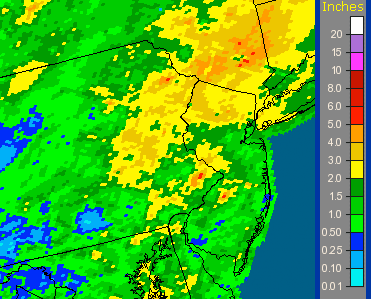
Saturday's rainstorm produced an usually large flow of nearly 5,000 cu.ft./sec down the creek.


This is a map the of rainfall over the last seven days in the watershed. Most of the rain fell in a single day, with a total in the range of 4"- 6" judging by the color code.

Friday, May 29, 2009

Scholar's Stone


A short distance from Horse Head Rock, another element in the Park landscape seems worthy of naming: Scholar's Stone. The shape of this feature suggests a mountain in miniature. Not in the tradition of Fairmount Park, where scholar's stones are more often in gardens, one might find beauty and inspiration by happening upon this outcropping in the Park.


Portland Classical Chinese Garden, with the pleasant name of The Garden of Awakening Orchids. Portland, Oregon.


Scholar's Stone is suggestive of the Asian appreciation of rock of the geological sort, as shown by the Chinese artist Xia Gui during the Southern Song Dynasty.


Tuesday, May 26, 2009

Bells Mill Road Bridge


Built in 1820, the Wissahickon Creek is spanned by the closed spandrel stone arch Bells Mill Road Bridge. With a total length of 66.9 ft. and a deck width of 24.3 ft., the span of the longest arch is 29.9 ft. Above is the upstream view and below is the downstream view.


The guard house has fallen into disuse and distance marker is no longer accurate.


The superstructure and substructure are generally considered to be in poor condition. The bridge has been appraised as being structurally deficient. Note how nearly 200 years of debris flowing through the arch at times of high water have chipped away at the voussoirs.

Thursday, May 21, 2009

Horse Head Rock


While all the bridges over the Wissahickon Creek have names, many other features seemed to have escape notice and demarcation. This particular rock, coincidentally near the Equestrian Center, looks enough like a horse's head to be worthy of this name. It is also located at the exact spot where the creek turns into the gorge with the hill of Chestnut Hill on one side and ridge of Ridge Avenue on the other.


Not as dramatic as Old Man of the Mountain, seen here in a picture from Belknap College, which is a composite showing the ghostly Old Man before his tragic demise on May 3, 2003.
The clarity of perceiving Horse Head rock is hampered by the leafing of trees in Spring.


The simple glare on the water surface can be remedied in a pinch by shooting the picture through the lens of polarizing sunglasses.


Thursday, May 14, 2009

Construction Begins on Bio-Composting Toilet


New life for the long-closed toilet on Forbidden Drive near the Rex Avenue Bridge. Construction has begun on a much needed 'green' facility. This follows on the first bio-composting toilet built near the Kitchen's Lane entrance to the park.


Sunday, May 10, 2009

Fungus Among Us


This fungus appeared yesterday on the side of Forbidden Drive south of Bell's Mills. A search online matches this with a Laetiporus sulphureus mushroom otherwise know as "Chicken of the Woods."


This appeared in the May 7, 2009 edition of the Chestnut Hill Local.

Saturday, May 9, 2009

In Search of the Source of the Wissahickon Creek Part II


The Montgomery County Planning Commission prepared the underlying map of the Wissahickon Creek Watershed. The intersection of the two red lines is at the Germantown Avenue Bridge. To find the source of the creek, the two red lines indicate the two most distant points from the bridge. Of the two lines, the one to Montgomeryville is clearly the longest, indicating that this must be the area where the source can be found. As seen previously, the alternative definition of the source states that "the furthest point from which water could possibly flow into the ocean," suggests that it is found on the watershed boundary. The map does not provide sufficient information as to the precise location source.